
{{product.productLabel}} {{product.model}}
{{#if product.featureValues}}{{product.productPrice.formattedPrice}} {{#if product.productPrice.priceType === "PRICE_RANGE" }} - {{product.productPrice.formattedPriceMax}} {{/if}}
{{#each product.specData:i}}
{{name}}: {{value}}
{{#i!=(product.specData.length-1)}}
{{/end}}
{{/each}}
{{{product.idpText}}}

... platform for projects and connect with Civil 3D and InfoWorks ICM in the Autodesk ecosystem. Spend less time switching software and more time solving drainage challenges to drive efficiency, quality, and results. Streamline approval ...
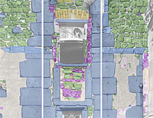
... Structured CAD data Damage Visualisation Action planner Mapping of damages and findings MonuMap is the software solution for mapping existing building conditions. It is widely used in the fields ...

... Export 3D-MC files Import/Export road alignments Projection, datum, and geoid Support Merge TIN surfaces Cut/ Fill color mapping and volume calculation Sitelink3D remote connect/file transfer/messaging ...
Topcon Positioning Systems Inc
... large selection of export formats provided by Z+F LaserControl®, data can be imported and further processed in all common 3D software applications. With Z+F LaserControl®, the entire scanner hardware can be conveniently controlled. ...
Zoller + Frôhlich

... >
Technical specifications
- Product type: Modular product visualization and marketing platform (software).
- AI feature: Automatic placement and image integration of materials into customer photos (AIphoto).
- Integration
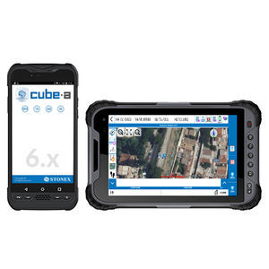
Cube-a is Stonex’s solution for professional surveying and GIS which has been designed and developed for the Android platform. Thanks to the flexibility of the Android environment, we have been able to create a simple and intuitive user interface that ...
... On-Site Photo is a software program for determining accurate dimensions from digital photos. The distinctive feature of this software is its simple operation. On-Site Photo is a universal tool to enable you to determine ...

... Intergraph offers image processing and feature collection extensions that expand the core capabilities of the ArcGIS platform. These extensions include: Stereo Analyst for ArcGIS: Create and maintain comprehensive databases of feature data using stereo ...
Intergraph
the best suppliers